

**This product is on liquidation, Price**
***Available While Supply Last***
 This product is available on international purchase on ebay
Unparalleled Coastal Chart Coverage
- Provides industry-leading coverage, clarity and detail with updated coastal charts that feature integrated Garmin and Navionics® data
- Auto Guidance¹ technology calculates a route using your desired depth and overhead clearance and provides a suggested path to follow
- Includes Depth Range Shading for up to 10 depth ranges, enabling you to view your target depth at a glance
- Up to 1’ contours provide a more accurate depiction of the bottom structure for improved fishing charts and navigation in swamps, canals and marinas
- NOAA raster cartography² is available as a free downloadable feature via the ActiveCaptain® app
BlueChart g3 coastal charts provide industry-leading coverage, clarity and detail with integrated Garmin and Navionics data. Also included is Auto Guidance¹ technology, which uses your desired depth and overhead clearance to calculate routes and provide a suggested path to follow — overlaid onto your chart. NOAA raster cartography is also available as a free downloadable feature via the ActiveCaptain app. It gives your chartplotter paper chartlike views of NOAA-surveyed areas in which individual points of interest are labeled with corresponding longitude and latitude information. Worldwide coverage is available by regions as accessory cards or via download; each region is sold separately.
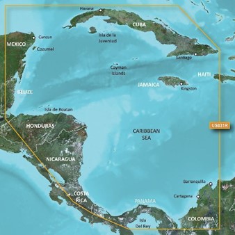
Coverage

Detailed coverage of the northern coast of Central America from Cancun, Mexico to Barranquilla, Colombia, including the Panama Canal in its entirety. General coverage of the northern half of the Gulf of Panama. Also includes detailed coverage of the coasts of Cuba, Jamaica, and the Caymans in their entirety.
Auto GuidanceWhether you are fishing or cruising, select a spot, and get a route showing you the general path and nearby obstructions at a safe depth1. |
 |
Depth Range ShadingThis feature displays high-resolution Depth Range Shading for up to 10 depth ranges so you can view your designated target depth. |
 |
Shallow Water ShadingTo give a clear picture of shallow waters to avoid, this feature allows for shading at a user-defined depth. |
 |
Detailed ContoursBlueChart g3 Vision charts feature 1’ contours that provide a more accurate depiction of bottom structure for improved fishing charts and enhanced detail in swamps, canals and port plans. |
 |
NOAA raster mappingThis function allows your plotter to visualize in the form of maps the areas listed by the NOAA in which the points of interest are labeled with the corresponding longitude and latitude information. |
 |
BlueChart Feature Comparison
|
Feature |
BlueChart g3 Vision | BlueChart g3 |
|---|---|---|
| Integrated Garmin and Navionics content | • | • |
| Auto Guidance¹ technology | • | • |
| Depth range shading | • | • |
| Up to 1' contours | • | • |
| Shallow water shading | • | • |
| Raster cartography² | • | • |
| High-resolution relief shading | • | |
| Unique 3-D views | • | |
| High-resolution relief imagery | • | |
| Aerial photos | • |