

**This product is on liquidation, Price**
***Available While Supply Last***
 This product is available on international purchase on ebay
Premier Coastal Charts
- Industry-leading coverage, clarity and detail with updated coastal charts that feature integrated Garmin and Navionics® content
- Auto Guidance¹ technology quickly calculates a suggested route by using your desired depth and overhead clearance
- Includes Depth Range Shading for up to 10 depth ranges, enabling you to view your target depth at a glance
- Up to 1’ contours provide a more accurate depiction of the bottom structure for improved fishing charts
- To give a clear picture of shallow waters to avoid, the Shallow Water Shading allows for shading at a user-defined depth
Experience unparalleled coverage and brilliant detail when you’re on the water. BlueChart g3 Vision coastal charts provide industry-leading coverage, clarity and detail with integrated Garmin and Navionics content.
Coverage

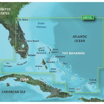
Detailed coverage of the Florida Peninsula from St. Mary's, GA through the Port of Miami to Fort Myers on the Gulf. Coverage includes the St. Johns River, Crescent Lake, Lake George, Lake Monroe, Lake Jesup, Lake Harney, Lake Okeechobee, the St. Lucie Canal, and Caloosahatchee R. in full. Detailed coverage also includes the Florida Keys, Bahamas and Turks and Caicos Islands. Bathymetric coverage of offshore features from Blake Canyon through Santaren Channel to the Torgtugas Terrace, including the Blake Escarpment and Great Bahama Bank.
Auto GuidanceWhether you are fishing or cruising, select a spot, and get a route showing you the general path and nearby obstructions at a safe depth1. |
 |
High resolution relief shading functionHigh resolution embossed shadows combine color and shadows to give you a clearer and easier to interpret vision of the background structure than the contour lines alone. |
 |
Depth Range ShadingThis feature displays high-resolution Depth Range Shading for up to 10 depth ranges so you can view your designated target depth. |
 |
Shallow Water ShadingTo give a clear picture of shallow waters to avoid, this feature allows for shading at a user-defined depth. |
 |
Detailed ContoursBlueChart g3 Vision charts feature 1’ contours that provide a more accurate depiction of bottom structure for improved fishing charts and enhanced detail in swamps, canals and port plans. |
 |
High-resolution Satellite ImageryHigh-resolution satellite imagery with navigational charts overlaid gives you a realistic view of your surroundings. It’s our most realistic charting display in a chartplotter — ideal for entering unfamiliar harbors or ports. |
 |
FishEye ViewThis underwater perspective shows 3-D representation of bottom and contours as seen from below the waterline. Interface with sonar data for a customized view. |
 |
MarinerEye ViewThis view provides a 3-D representation of the surrounding area both above and below the waterline. |
 |
Aerial PhotographyCrystal-clear aerial photography shows exceptional detail of many ports, harbors and marinas and is ideal when entering unfamiliar ports. |
 |
NOAA raster mappingThis function allows your plotter to visualize in the form of maps the areas listed by the NOAA in which the points of interest are labeled with the corresponding longitude and latitude information. |
 |
BlueChart Feature Comparison
|
Feature |
BlueChart g3 Vision | BlueChart g3 |
|---|---|---|
| Integrated Garmin and Navionics content | • | • |
| Auto Guidance¹ technology | • | • |
| Depth range shading | • | • |
| Up to 1' contours | • | • |
| Shallow water shading | • | • |
| Raster cartography² | • | • |
| High-resolution relief shading | • | |
| Unique 3-D views | • | |
| High-resolution relief imagery | • | |
| Aerial photos | • |